Gail and Jerry

HIEDI

HIEDI
HEIDI

Tsunami

Tsunami
Tsunami

Tuesday, August 9, 2011

Day 40 Soldonta

We started the day at the Visitors Information Center where Heidi found Fishing Dog Heaven.
                                    "Just the mention of my name, patrifies fish."
                               

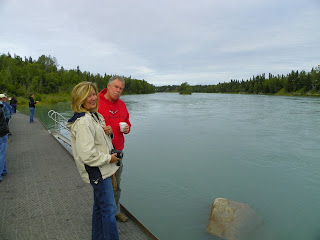
                                                                 The Kenai River, where the fish hang out, as well as some tourist.


Next, the wood carving store.

                                                          The wood carver at work.

Lon ordered 7 more chairs and a dining table. Pam is looking for new dishes. She is also planning some really big Dinner Parties!

                                    Gail didn't buy anything!!!  Except some Salmon Jerky for Heidi and Lon.

Next stop, the St. Elias Brewing Co.

Good beer and good pizza and Heidi was welcome.

Stopped at another wood carver in Kenai on the way to the beach. Hmm..."beach" in Alaska takes on a whole new meaning.

Heidi went fishing in the Cook Inlet.

This moose had a calf with her but it wouldn't come out of the brush.

It was 55* when we got to Stormy Lake, but these Alaska kids didn't notice.

This moose was  a bit bashful.

This one didn't care. She was hungery.

Did we mention there are flowers everywhere. These are Fire Weed, the state flower.

Pam is trying to get reservations at this RV park. It is close to the water so not many empty sites.
Tomorrow, a road trip to Homer to check out the coast. Maybe.


Monday, August 8, 2011

Day 39 Palmer to Soldolna

We left Palmer headed for the Kenai Peninsula. First we go south 45mi. Of course there is only one road. It goes through the middle of downtown Anchorage.

South side of Anchorage is a blow-up golf facility, I think a driving range. They have paint it to blend with the mountains.

Then comes the Turnagain Arm of the Cook Inlet, where we turn East for 45mi.

Just south of Anchorage, the Seward Highway hugs the dramatic shorelines of Turnagain Arm, arguably one of the most beautiful stretches of highway in America. Chugach State Park's 3000-foot mountains just up on your left. On the right, the sprawling, sometimes four-mile-wide flats of Turnagain Arm seem to stretch like a plain to the opposite shores of Cook Inlet, where mammoth sloping mountains abruptly stop their flat expanse. Each turn reveals another scenic wonder.


Heidi was wondering "what the hell is She thinking....this ain't no dog walk"


Then at the East end, we came upon the Portage Glacier. There we turned back South for 40mi.  (click on the pic to enlarge and hopefully you can see the blue of the ice)

The road South took us into the mountains.

A bladder break .


Then we turn back West for 65mi.

Fishing on the Russian River.

Rafting on the Russian River.

And we landed in Soldotna.
Tomorrow we are going to do something else.


Sunday, August 7, 2011

Day 38 Hatcher Pass expedition

Today we went to Hatcher Pass, a beautiful drive on some of the highest, most spectacular, and wildest roadway in the state. The pass is 3,886 feet. On the way up we stopped along the Little Susitna River which starts at Mint Glacier in the Talkeetna Mountains, and flows 13 mi. to the Cook Inlet.
                                                     Remember.....click to enlarge pictures!
                                           These 2 people, from California, were panning gold.
                                                            This 3 were just panning.

We stopped at a scenic overlook for a look back from where we came.

                              Next we found a dirt road...AND we just can't resists a dirt road. As it turns out it was the road to Archangel Valley, which is where you go for hiking, biking, rock climbing and bouldering...what ever that is. The road was 3 miles and seemed like 10!

Lon discovered some foot prints in the road.
A Bear!

AND A Moose!
Beaver Pond


This is where all the hikers, bikers, rock climbers and boulerers leave their cars. But for the life of us we couldn't see a single person out there anywhere! Hope the bears didn't eat them.


This is Independence Mine from afar.

In 1942, the War Production Board designated gold mining as nonessential to the war effort. Gold mining throughout the United States came to a halt, but Independence Mine was permitted to continue to operate because of the presence of scheelite, an ore of the "strategic mineral" tungsten, which occurs in the quartz lode with the gold. In 1943, Independence Mine was ordered to close. Mining interests returned to Hatchers Pass when gold prices rose in the mid-1970s; this resulted in a short period of production from the Independence Mine in 1982 by Coronado Mining Company.[5]
Today, Independence Mine is a part of the Independence Mine State Historical Park, a popular winter recreation area. Displays of mining artifacts may also be viewed at the Dorothy Page Museum and Old Wasilla Townsite in downtown Wasilla, Alaska.


This very nice Park Ranger helped Pam identify some of Alaska's wild flowers.


Cotton Grass
 He also showed us Placer Gold which is gold embedded in granite. Lon tried to get away with it. And as you can see Heidi is listening intently. She is such a good student.

As we were leaving we noticed pill droppings in the parking lot. This family brought their pack goats to carry their supplies for the days hike. This was the ENTIRE family...Grandma, babies, puppies and all!

The road to the summit. 3886 ft.

And here we are at 3886 ft. freezing our...well, you know.

 Lon volunteered to stay behind to take this picture. Remember to click the pic to enlarge. See Pam, Gail, Heidi and me. You may have to click twice to see Heidi.

Summit Lake.

The road home.

Lon just HAD to stop and get some of that gold from the Little Susitna River. Something about paying for their trip?

When we got home, Lon cooked brats and baked beans. Yum yum.
We all had a GREAT Alaska Day.